

Points of Interest
MAP
Protych Tract

The Protych tract combines powerful river rapids, picturesque rocky islands, and steep cliffs formed by geological formations of the Ukrainian crystalline shield, over 2 billion years old. These ancient granites preserve relic life forms, as well as rare and endemic species of flora and fauna. It is a one-of-a-kind location in Ukraine, where dramatic water flows, natural obstacles, and rugged cliffs attract outdoor enthusiasts and adventure seekers.
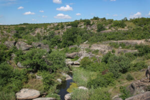
Aktove Canyon
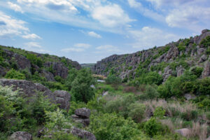
Aktove Canyon is a unique natural formation where steppe and aquatic ecosystems meet, featuring towering cliffs and massive granite boulders across an area of more than 250 hectares. Travelers are suddenly confronted with a granite abyss rising out of the open steppe. The dense clustering of rocks along the Mertvovod River creates an almost surreal atmosphere, where sunlight reaches only at midday. The canyon captivates visitors with its mystique, scenic beauty, and sense of remoteness.
Arbuzynka Canyon
Located near the confluence of the Arbuzynka River with the Mertvovod, this canyon impresses with its unusual rock formations, scenic landscapes, and a pleasant microclimate shaped by the nearby water.
Labyrinth Tract
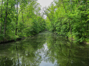
The Labyrinth tract is a man-made oak grove, largely planted in 1825 by the renowned forester Viktor Skarzhynskyi as part of a landscaped estate park. It features a system of canals, dams, and artificial waterfalls constructed along the Arbuzynka River. The area is home to 200-year-old oak trees.
Gard Tract
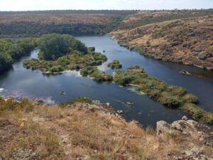
The Gard tract lies 2 km southeast of the village of Bohdanivka and 1 km south of the city of Pivdennoukrainsk. It is a narrow and deep canyon with steep rocky banks, where the Southern Bug River (historically known as the Bog (God) flows among massive granite boulders, forming a large rapid over 1 km long. On the left bank stand three easily recognizable cliffs — Owl Rock, Gate Rock, and Eagle Owl Rock. They shape the distinctive landscape of the canyon and have long served as natural landmarks. Opposite Eagle Owl Rock lies Gard Island, covered with shrubs and trees, marking the end of one of the largest rapids on the Southern Bug. Historically, “gards” referred to fishing structures, and the tract takes its name from a Zaporizhian Cossack fishing site once located here. Regarding the location of the Gard, a researcher notes, in particular: “This place was initially intended solely for crossing the river and fishing in it, but later, already in the 17th century, it was transformed into the main frontier guard post, or palanka”.
Radon Lake

Radon Lake was formed at the site of a former granite quarry, filled naturally by groundwater. Its depth reaches up to 24 meters. The lake is known for its exceptional clarity and striking color. It derives its name from the presence of dissolved radon gas (Rn), though its concentration remains within safe limits.